
| Date | 9/11/2026 |
| Location / Trail | Mcintyre Ridge, Douglas, Plaza, Boulder Ridge Trails - 782, 781, 783, 783A |
| Weather | Sunny but not too warm |
| Hiking Buddies | Oliver, Paige and Thor |
| Start / End | 10:10 AM – 6:25 PM |
| Distance / Elev | 14.3 miles 3200 ft elevation |
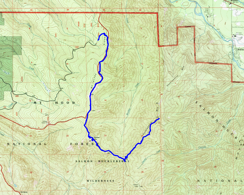
WOW! Two epic hikes in one week! I think that is a record for me…. Today’s hike was not intended to be epic or nearly as long as it turned out. We were just having a good time on trails that none of us had been on before (or at least not in the long time) and we just kind of kept going (maybe a little longer than we should have 🤣). It all worked out really well, and it was really interesting to see these trails.
The plan for the day was to start at the “New” McIntyre trailhead and hike south to Wildcat Mountain. I had hiked a little bit of this area in 2021 when we did a big backpacking loop that came down the Douglas trail and then down the Plaza trail. We would re-trace a little bit of that trip today.
Oliver had been in touch with Paige, who we just met on Monday (Labor Day) when we ran across her on the trail and she ended up joining us on my last epic hike. She was interested in coming on this hike, so we all met in Estacada and then drove up Wildcat Mountain Road basically to the end where the “New” trailhead was supposed to be. We didn’t actually drive all the way to the end because the road was in pretty bad shape. We all kind of laughed at the “New” moniker – nothing about this trailhead looked new (or improved). We stopped and parked at a wide spot a bit from the end. We suited up and headed to the end of the road where it was obvious a lot of off-roaders come in and tear the area up. I think what has happened over the years is that they basically drove up the trail quite a ways. All the “roads” that go up from the trailhead essentially follow the path of the trail on the map. We did a few side trips to look for trail on either side of the road but didn’t find any, so our assumption is the road is the trail – at least for about the first mile or so.
Near the end of the road, the trail heads out to the edge of a dropff to a campsite, a cross memorial (which looked really recently built) and a bench. This would be the first of many views of Mt Hood during the day. It wasn’t too far past this area where the road abruptly stops and a real trail begins. The forest in here is very open with very little undergrowth:

A bit farther up the trail, it opens up into a really neat beargrass meadow – the beargrass in here was probably over a foot tall and very thick:

A little bit further up the trail is what used to be a really nice memorial bench – it was in pieces unfortunately. It was in a kind of open area – I wondered if this area might have been an old helispot? It was interesting – one of the names on the bench appeared to be the same name as the new memorial we saw a little bit earlier on the trail:

This open area provided another good look at Mt Hood and the surrounding area. It was perched at the top of a big rockslide that was starting to show fall colors already:

And eagle eyed Paige noticed this very interesting rock spire below the trail to the northeast:

After enjoying the view for a few minutes, we continued on down the trail. This trail is mostly a ridge trail, so there are quite a few ups and downs on it. It reminds me a little bit of the Baty Butte trail, which does the same thing.
We soon got to the junction with the Douglas trail and we continued south. The trail in this area was really good. You could tell this segment gets more traffic and more maintenance. It was easy walking in here. It wasn’t too long before we got to the short side trail up to Wildcat Mountain. I had been up here on the backpacking trip in 2021, but there had been a fair amount of snow at the time. We took the steep side trail up to the top of Wildcat Mountain. As soon as we got there, I remembered exactly what it was. There used to be a lookout here long ago, but it has all grown up with rhodies and trees, so there is zero view from here. Kind of a bummer. Paige noticed a side trail in the rhodies so we followed that for a bit but it kind of petered out, so we went back. Oliver said he found an open area with a bit of a view so we headed back there and had some lunch. The views weren’t great but we could see Mt Hood if we stood up.
During lunch, we talked about what we wanted to do. We ate kind of a late lunch – it was approaching 1:00. This originally had been our turnaround spot, but no one really wanted to stop here. We knew we couldn’t go too much farther, so we talked about some turnaround spots. We decided to check out Coffman Camp, the campsite we used in 2021. After that discussion, we packed up and decided to just bail off down the hill back to the trail instead of going back. It was kind of difficult fighting thru all the rhodies but we soon got back to the trail and continued our trek south.
A little south of Wildcat Mountain we got to another open spot – there was what looked like a side trail so we followed it a bit. It didn’t seem to go very far but it looks like it was an old campsite – we found what we think was an old firepit. That was kind of interesting. Near this open spot was an interesting framed view of Mt Hood:

We continued our walk south and soon came to the junction with the Plaza trail. We had been on this trail just a few days ago – on that trip we headed east over to Salmon Mountain – that junction was a couple of miles south of where we were today. Not too far past the junction with the Douglas trail, it starts descending underneath a really interesting rock wall:

And a bit farther was this interesting rock outcropping above us:

You could tell that this part of the trail didn’t get nearly as much traffic as the segments we did earlier. The trail was quite a bit brushier and there were a number of downed logs:

Even though it was rougher than earlier segments, it wasn’t hard to follow and we were making pretty good time. We soon got to another interesting open area:

And shortly we got to a kind of confusing junction. The maps we had showed the Plaza trail continuing north and the Bonanaza trail heading off to the east, but the sign here said this was the Boulder Ridge trail – it didn’t show a trail number but the sign was definitely newer. The trail heading to the right is the Bonanza trail that heads east:

The Boulder Ridge trail started really interesting – there was a huge rock outcropping a the junction and then you got up on top of the rock which was a really flat spot – it almost looked like an old road:

Past that flat spot the trail continues up and soon goes below Huckleberry Mountain. There was really no trail to the top, and when we got up there, we kind of realized why – you can’t see anything from the top of Huckleberry Mountain:

It was a little disappointing, but we can say we’ve been to the top of Huckleberry Mountain now. At this point it was after 3:30 – we had been on the trail about five and half hours and we were over 7 miles from the trailhead. We knew it would be a faster trip back since there was more downhill than uphill (although we would still have a good bit of elevation since the trail goes up and down so much). We were hoping we could make it back in 3 hours if we didn’t dawdle. We turned around and headed back.
We were more focused on the way back – we had kind of taken our time on the way up, but if we were going to get out of there before dark, we knew we needed to make some time. The trip back was pretty uneventful, although we heard some Friday night shooting in the distance which was a little concerning. We made good time on the way back and we ended up getting back to our vehicles a little under 3 hours from when we started on Huckleberry Mountain. It was a hike that started out as a decently long hike (7ish miles out and back) that evolved into over 14 miles on some really, really interesting terrain, with lots of views and interesting sights.
I think we will be back to re-visit this trail – and this area again.