
| Date | 10/21/2026 |
| Location / Trail | Fish Creek Mountain - 541 |
| Weather | Sunny |
| Hiking Buddies | Thor |
| Start / End | 10:25 AM – 2:35 PM |
| Distance / Elev | 6.2 miles 2000 ft elevation |
| Logs Cut | 12 |
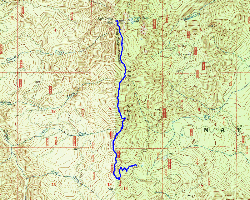
Today’s hike was simply a “get out in the woods” hike. I looked at options and Fish Creek Mountain was close and was accessible – there are other trails I’d like to do, but they are still inaccessible due to closures for the Austin fire.
We headed up a little later than usual, partly because it is relatively close. We headed up the 4620 road and a couple miles up I was surprised to see a Clackamas County Sheriff truck on the side of the road. I almost stopped to ask what he was doing that far out, but I didn’t. We continued up the 4620 road and arrived at the trailhead (the former continuation of the 4620 road), parked, suited up and headed up the trail.
As we were headed up the trail I was thinking “wow, this trail is getting used by someone”. It wasn’t too much farther and I realized it was not a person but a motorcycle. Thankfully, it didn’t go too far before that evidence disappeared. Not too far up the trail we encountered the first new downed tree – this is what it looked like before (it was quite a mess with all the branches):

And then after I spent a few minutes limbing it up – it is now a pretty easy stepover:

A little bit farther up the trail was another similar tree – before:

And after a few minutes limbing this one up – again, a pretty easy stepover now:

I was a bit surprised since this trail was completely logged out earlier this year, but with all the burn damage it is inevitable that more logs will fall. I’m glad I was able to make these logs easily passable again. There were a couple more up the trail, but they didn’t have limbs like these two and were easy to step over.
We continued up the trail – the trail below the road was really in pretty good shape except for the handful of new logs. We got up to the road and headed down the road. There were no new logs along the road, but there were a few areas that were pretty brushy. We soon got to the spot where the original trail headed up and we started up. Just up the trail from this was an old sign that Donovan had made – I don’t know how old it was but it had to have been over 20 years old. I was sad to see that it had finally succumbed to the fire:

I took this picture in 2024 – it had survived the fire – it was this way until this trip so it failed relatively recently:

I think the wood just dried up and split. I found a couple of pieces of the sign but couldn’t find the upper part of it:

We continued up the trail. As we went I threw branches off the trail and moved a few logs off the trail and also cut two or three of them. I think there was only one log on this upper part of the trail which was nice.
As we were headed up I started looking at the time – I was getting hungry. It was getting close to noon. I figured we could eat at the top so I kind of stopped doing work on the trail and we just headed up. Even with that, we didn’t get to the old lookout until about 12:40, so we had a late lunch. After eating, I looked around a bit and took a few pictures. I noticed it was really smoky to the south and after looking at the map, it was smokiest in the direction of the Austin fire, so I’m guessing it is smoking a bit more now – or they are burning some areas or something – it was definitely a lot smokier than I’ve seen in a while:

I walked around and noticed a bunch of deer prints and even some elk prints, although the elk prints got stepped on – but deer certainly seem to like it up there:

After looking around a bit it was already after 1:00 and I intended to be home by mid to late afternoon, so we needed to head back down. Due to the time, I didn’t think we’d have time to go down to high lake – I think that was a good call because that trip would have taken us at least an hour which would have put us home much later than I wanted to. I also figure it would have taken more than an hour – you get looking around, etc and it takes longer than you think.
After deciding to skip the side trip to the lake, we headed down the hill. I don’t remember exactly where this was, but at some point on the way down, I noticed an insulator sitting on the ground next to the trail. I don’t remember seeing this before but it was cool to see it:

After seeing the insulator, the rest of the trip down the hill was pretty uneventful. We made pretty good time going down the hill. It took us about 2.5 hours to get up to the top – I was thinking we could get down in about 1.5 hours. We ended up getting down in just over 1.5 hours so I was pretty close.
We packed up and headed home – it was a really nice day in the woods today. Even though the majority of this trail is burned (some of it significantly), it is still an interesting trail with some really good views.