
| Date | 10/29/2026 |
| Location / Trail | Three Lynx Way Trail to Grouse Point - 517 |
| Weather | Foggy, cold, rain, snow |
| Hiking Buddies | Thor |
| Start / End | 9:50 AM – 2:05 PM |
| Distance / Elev | 6.5 miles 1200 ft elevation |
| Logs Cut | 10 |
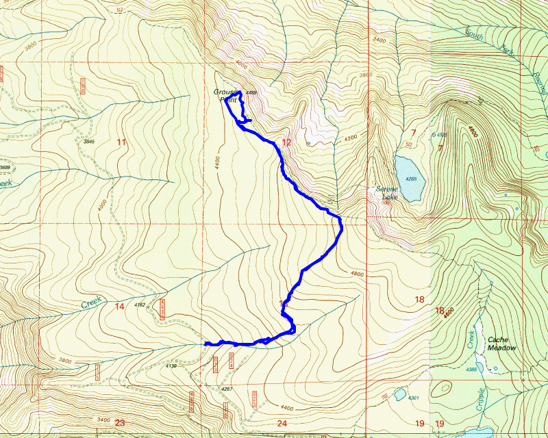
Today’s hike promised to be an interesting one. I was considering doing it the day before but the weather report didn’t look great – given what I encountered I’m REALLY glad I delayed. It was quite an adventurous day – I termed it cold, wet, miserable, and very interesting all at the same time.
The plan was to hike up the abandoned Three Lynx Way trail to the Grouse Point trail – it intersects it a bit east of the trail down to Serene Lake. The plan was to head to Grouse Point and then look for the supposed side trail over to Grouse Point. If I couldn’t find one, I would lop out a path to Grouse Point – one thing made this extremely difficult – I left my loppers at home! I realized that fact when I was about halfway to the trailhead.
We started out a little early – the weather report didn’t look too bad – it wasn’t going to be clear and dry, but it wasn’t supposed to rain much, if at all. We headed up the 4635 road and when we were a good ways up the road, there is a spot with a bit of a view – I took this cool picture of the fog in the valley below:

We got to the “trailhead” (there isn’t one since this is an abandoned trail) – I parked in a wide spot in the road. It wasn’t raining when we started but the truck said it was 36 degrees. We suited up and headed out. I saw a small opening in the trees and went in – by sheer chance, I found the lower end of the Three Lynx Way trail – when we were here last, we lost the end of it in some blowdown. We followed the trail up and I soon saw where we lost it last time. From there, we followed it up to where it stops at an old cut. This was where we got our first look at a bit of fresh snow:

We walked our way around the edge of the cut (that is the easiest way to negotiate it) and soon picked up the continuation of the trail and continued our trek north.
We cleaned up a couple areas that were difficult, doing a bit of limbing of downed logs to make it a little more evident where the trail went. At some point, it started lightly raining – but I was prepared, as I had put on my raincoat and rain pants – I figured even if it didn’t rain, all the brush was going to be soaked. As we got a bit higher, it actually started snowing:

A bit higher on the trail there was an area that was pretty open – in this area there was probably about an inch of fresh snow:

And there was evidence of recent deer activity in the snow (to the right of Thor’s print):

Of course, since this was his first snow of the season, Thor had to play in the snow a bit:

I looked at my phone and I hadn’t really realized that it was so high up here – we were at almost 4800 feet!
It wasn’t too long and we got to the junction with the Grouse Point trail. We headed west/north and continued our trek. The trail was in great shape to the junction with the Serene Lake trail. There were a few freshly cut out logs, but that abruptly changed after the junction. You could tell that a lot of people come up from Serene Lake and make a loop back to Cache Meadow – going north from here isn’t a well used route. There were a bunch of downed logs after the junction.
I think the last time I had been in this area (near Grouse Point) was way back in 2008 – I think that might have been the only time I’d been up here. I distinctly remember when going thru this area the rhodies were overgrowing the tread – I was curious what it looked like now – 18 years later.
The area around the Serene Lake trail junction is kind of like the Rimrock trail – established forest with lots of space under the trees and lots of beargrass – but easy walking and very few rhodies. I was expecting to see LOTS of rhodies around Grouse Point. As we started approaching Grouse Point, we started getting more rhodies but it was still really clear – I was hopeful – maybe someone had done some significant brushing at some point in the recent past?

Those hopes were pretty quickly dashed – not very far up the trail it turned into an overgrown mess – you can see Thor’s orange vest – he is on the trail:

At this point, I was really glad I was fully suited up in rain gear – the rhodies were wet and many of them had wet snow on them as well, so pushing thru them got you wet in a hurry.
We hadn’t gone too far when I saw what looked like a side trail – there was supposed to be a side trail to Grouse Point at one time. I thought we’d try and follow it. It quickly devolved into fighting head high (and higher), THICK rhodie thickets. It kind of felt like I was walking in circles at one point but I got on a good direction. We should have turned back and continued down the trail but by the time I considered that, it would have been more work to go back so we fought our way thru the rhodies. Thor had a really hard time in here – we kept getting separated as he kept looking for an easier way – there really wasn’t one – just push thru the rhodies.
I kept making sure I was going in the right direction – with few landmarks and rhodies in all directions it was kind of disorienting, but after what seemed an eternity, I finally made it to a small open spot which was the beginning of Grouse Point proper. Thor caught up to me and we made it out onto the old flat area that had been cleared years ago. We were both soaked.
I took some pictures, but you couldn’t see a whole lot today. This was from where we stopped, looking into the South Fork Roaring River drainage:

There is a big rockslide below the point which I had never realized. We stopped and ate some lunch – thankfully, it was not too windy – I put on my hat (which was also soaked) and my puffy under my raincoat – my hands were pretty cold and my heated gloves were soaked as well. I put one heated glove on one hand, set it on high and put my other hand under my armpit when I wasn’t eating to help it warm up. My hands have definitely been colder, but they were cold enough up there.
After eating, we walked around a bit. I found a couple of spots where there was the old yellow “tape” (not sure what to call it) where they marked the old helispot landing pads. I think this cleared area was where they cleared to make the helispot. There was also supposed to have been a temporary/emergency lookout on Grouse Point (https://www.trailadvocate.org/document-transcript/?doc=113). Here is a picture of one of the old “tape” areas (I found two of them) :

This was what the whole open/cleared area on top looked like:

It was a good thing I looked around and took a few pictures before eating lunch. After we ate lunch, the clouds rolled into the valley – you couldn’t see anything down in the South Fork Roaring River anymore:

As I was looking around, I noticed what appeared to be sort of a trail heading mostly west – it was the shortest route back to the trail:

I decided that was going to be our route back – we would still have to fight rhodies but it wouldn’t be too far. We packed up our stuff and then headed that way. The rhodies over there were just as thick as they had been coming up here, but thankfully, it was quite a bit shorter. It wasn’t too long before we made it back to the trail. Once on the trail, we still had to fight the rhodies for a while since they were overhanging the trail, but that was a walk in the park compared to what we fought getting up to Grouse Point.
Pushing all those rhodies out of the way got me a bit wet even with full rain gear – I didn’t have my raincoat zipped all the way up, and snow got down my neck a few times. As the snow was really wet and sloppy, it got my shirt wet. As long as we kept moving, it wasn’t a problem.
It wasn’t too long before we got thru the rhodie hell on the trail and we were back to nice, open trail again. We got back to the junction with the Three Lynx Way trail and headed south. There were a few spots where we scratched our head a little bit but mostly it wasn’t too hard to follow – at least until the cut. When we got to the cut we walked the edge of the cut and tried to find where we found it continuing on the south side – I ended up finding an old flag which also looked like tread but it kind of petered out pretty quickly More exploration needs to be done in there to see which alignment is correct.
We soon made it back to the truck. By this time, the sun had started to come out a bit. It was still cool (I think the truck said 39 degrees) but I was glad to be back at the truck. We piled in and headed out. Before we headed back, I thought I’d drive up the 4635 road a bit to see how good it was. Prior to the 140 spur (that goes up to Cache Meadow and the Rimrock trailhead), the road has gotten bad in spots, especially in the burned areas. I only drove up about a mile and a half, but the road is in really good shape to that point. I had thought about seeing if I could drive up to the point where the Dry Ridge side trail meets it, but that was about 4 1/2 miles from where we parked and I wasn’t really ready to go that far today. Maybe next year.
It was a really good day today – tough, but really interesting. I can honestly say I will not ever fight those rhodies again to get out to Grouse Point, but maybe we can do a work day when we brush out the main trail, and cut a path out to Grouse Point – something along the line of where we cam out. I guess we will see how things work out next year.