
| Date | 10/14/2026 |
| Location / Trail | East End of Rimrock Trail - 704 |
| Weather | Mostly Sunny |
| Hiking Buddies | Thor |
| Start / End | 10:15 AM – 1:30 PM |
| Distance / Elev | 4.3 miles 1200 ft elevation |
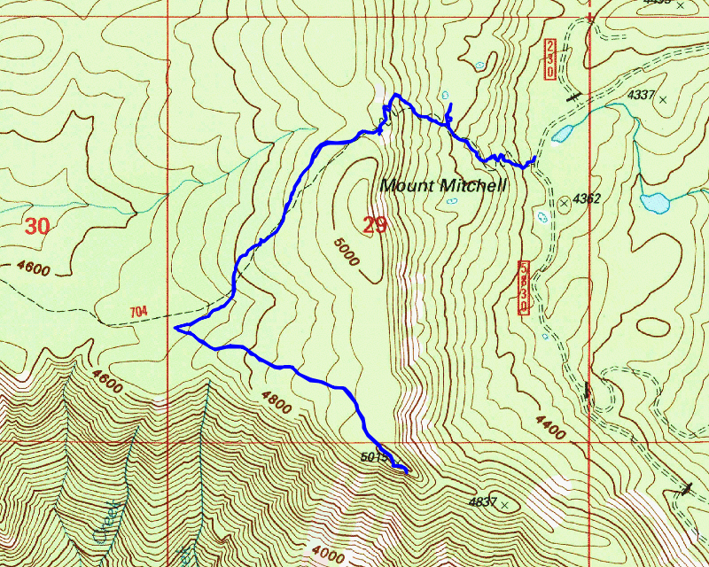
Today’s hike was simply a “get out in the woods hike”. We’ve continued to have some BEAUTIFUL fall weather – it is a bit chilly in the morning but it warms up pretty quickly and has been sunny or mostly sunny. Temps have been in the 50s or 60s up high, which is good hiking weather. I want to take advantage of this nice weather and get out as much as I can – while I can before the weather turns rainy.
Since I will be doing 3 back to back hikes, I decided to do a relatively easy one today – going back to the East end of Rimrock and up to the overlook. I could probably hike to that overlook every day and never tire of it.
We headed out at the usual time and made pretty good time to the trailhead. As we were headed up the 5830 road there was a truck parked right in the middle of the road – he was cutting a log (I’m guessing firewood). Fortunately, we were able to squeeze by him. We got to the trailhead, suited up and headed up the trail. The first half mile or so of the trail is mostly pretty steep with a few short flatter sections. Once up at the rockslide, the trail starts a gentle downhill to the junction with the overlook trail.
As we were headed up the hill, I noticed some green flagging and a faint trail heading off a switchback. The trail headed north, but I’m not sure where it would have gone. The only thing I could think of since it does not appear on any maps I have is that it was some sort of administrative trail up to the old alignment of the Cottonwood Meadows trail. Here is the junction – Thor is on the current trail and this side trail heads basically straight:

After that short side diversion, we continued up the trail. Once we got to the rockslide, we started our gradual descent. Last time I was here there were several downed logs and a couple of really messy areas. I decided to do a little work on them to make passage easier – I couldn’t cut the logs out, but at least it is easier to get over/thru these areas now. Here is the first one before:

And then after I got done doing a lot of clearing on this blowdown – it is now relatively easy to get over/thru:

A bit farther down the trail were a couple of very limby logs which are difficult to get thru without getting poked. This is what they looked like before:

And after cutting several of the limbs off:

A little farther was the worst mess – this is what it looked like before I did anything:

And then after a bunch of cutting and moving of branches:

After cleaning up some of those messes, we soon got to the junction with the overlook. Thankfully, from this point on, the trail has all been cleared so it was smooth sailing to the overlook. We got to the top and went out to the end and had lunch.
When we first got there it was a bit cloudy but the sun came out and it was beautiful up there. A slight breeze (as is usual) with great views today. The last time I was up here a few weeks ago, I took some closeup photos of Oak Grove Butte to see the fire damage. Today, you could see some small areas that were smoldering from the remains of the Austin fire. This closeup was on Oak Grove Butte:

Another smoldering area a little bit west of Oak Grove Butte:

I took this closeup of Whalehead with what I think is somewhere up the Memaloose (45) road – you can see what appears to be another one of the big radio antennas:

And of course I couldn’t neglect some of my favorite subjects – Olallie, Mt Jefferson and the 3 Sisters:

After spending a while enjoying the view, Thor was complaining – he wanted to go down. So, we packed up and headed down the trail. We made really good time on the way back and got back to the truck about 1:30.
Since it was still kind of early, I thought it would be interesting to hike a short trail I’ve not hiked before – I wasn’t even aware of it for a long time. It is the short trail that goes from the south side of 5830 where the Shellrock Lake trail parking area is down to Hideaway Lake. I think it is supposed to be part of the Shellrock Lake trail. We parked at a “road” that went downhill to a wetland/meadow south of 5830. When Oliver and I were in this area a couple of months ago, there was a forest service fire truck parked there since the Shellrock Lake parking area was full of vehicles – they were all working on the Mitchell fire which had been burning above Shellrock Lake.
We headed down the trail. I had to take a picture of the Meadow/Wetland area:

The trail follows this meadow/wetland area pretty much the whole way to the lake. It meanders along the edge a bit before heading pretty much due south and shortly comes to a junction with the trail around Hideaway Lake. Hideaway Lake is a beautiful lake – I took my dad to go fishing here probably close to 20 years ago now.

We walked up the trail a short ways but I didn’t really want to walk all the way around the lake, so we turned back and headed back to the truck. It was a quick trip – I think the whole thing only took us about 20 minutes but it was interesting and I’m glad I finally saw this last little bit of trail.
It was a good day out – another gorgeous fall day – I don’t know how many more of these we will have but I plan to take full advantage of them as much as I can.