
| Date | 3/2/2026 |
| Location / Trail | Cache Meadow, Grouse Point, Serene Lake and Three Lynx Way Trails - 702, 517, 512 |
| Weather | Mostly cloudy with a few sunbreaks |
| Hiking Buddies | Kirk and Thor |
| Start / End | 11:15 AM – 5:05 PM |
| Distance / Elev | 10.1 miles 2000 ft elevation |
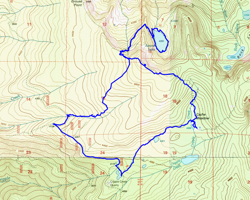
Today’s trip was intended to be a different destination, but since Oliver was not able to come, we decided to do another loop that I’ve been looking at. It turned out to be an awesome trip!
We got a bit of a late start today but we made it up to the trailhead a little after 11. There was a LOT of activity in Ripplebrook due to the Austin fire but once we got a little ways up the 4631 road we didn’t see anyone else all day long. We parked the truck at the Cache Meadow trailhead, suited up and headed out. It wasn’t long before we got to the first of the many meadows:

This is right near the really confusing series of junctions near the beginning of this trail. You can go 3 directions – one goes up the Cache Meadow trail, one goes down to the “Trail X” (the trail that heads out to Cripple Creek lake) and I forget where the 3rd one goes – but it is all very confusing, especially when you haven’t been there in a while.
We knew where we were going, so we headed up the Cache Meadow trail. We quickly saw recent maintenance and it wasn’t too long before we saw some really large cut logs:

We continued up the trail and soon got to what I call Cache Meadow proper. We walked down the trail past the junction heading north down to the spot where the old cabin was – this is where the Cripple Creek trail comes in and meets the Grouse Point trail. We looked around a bit and then walked out to the meadow. This is one of the larger meadows at Cache Meadow and part of it still had a bit of water in it. In the winter this whole area would be full – this is a shallow lake – you can see where some kind of animal was wallowing in the mud in the lower right of the picture:

We walked back up the trail to the junction where Grouse Point heads north and started on the trail. The beginning of this trail is pretty flat, as it follows the Cache Meadow flat area and the beginning of Cripple creek until it starts climbing. Once it starts climbing it really starts climbing. About half way up you get a short reprieve in a flat area and then it continues its climb to the top of the ridge. It gets up to almost 5000′. At this point the trail levels out with just a little up and down and it follows the ridge above Serene Lake.
It was past lunch time and there is a nice viewpoint at an old helispot along the ridge. The helispot isn’t quite as good of a view as it used to be as some of the smaller trees are growing up. Kirk found some open rocks with a better view, so we sat there and ate lunch. This was our view – we could see 4 mountains today! (St Helens, Ranier, Adams and Hood):

After lunch, we packed up and continued down the trail to the junction with the Serene Lake trail. We headed down the trail – the sign at the top says it is 1 mile to the lake. The first bit goes down pretty steeply, in 5 switchbacks. The trail then is mostly level for a while as it heads around the nose of the interesting rock spire formation above Serene Lake.
After heading around that nose, it starts dropping down to the west side of the lake. You drop right down into a large campsite that has the only picnic table:

It was a lot nicer weather than the last time we were here – that was about two years ago on another epic trip when we did a Mid November trip in the snow – it was a very cool day but it was pretty windy and cold at the lake.
We looked around a bit and I wanted to go look at the big rock at the south end of the lake where I fished back in 2004 when we backpacked in here and stayed a couple of nights. We walked down there, looked around and Kirk saw another campsite around the lake so we went over to look at that.
We continued around the lake and soon got to the campsite. It gives you a much different view of the lake from the south end:

When looking at where we were on the lake, we realized we were almost half way around – the trail seemed to continue so we decided to go all the way around the lake. I’d never done that before.
The trail was a bit faint in places and there were spots with blowdown, but it wasn’t a difficult hike around the lake. When we got to the north end, somewhere around the small rockslide over there, I took another picture looking at the lake to the south – you can see the ridge above the lake where we came in:

We continued walking around the lake – the trail eventually intersected the Serene Lake trail coming from the rock lakes basin, which we followed across the outlet of the lake. It was at this point where Kirk noticed another “trail” – I had always followed the trail to the left, but he found a route to the right. I followed the one to the left, he followed the one to the right. What he found was indeed the original trail, as it had blazes. The route I’ve always followed is (I think) a re-route due to some blowdown on the original route. They converge back together not far beyond the outlet crossing.
We made it back to the campsite where we started. We noticed some ducks swimming in the lake which was pretty interesting – Thor decided to cool off in the lake but that didn’t seem to bother them – I guess he was far enough away:

By this time, it was almost 3:00 I think. Days are getting short and we still had to get back to the truck before dark. Sunset was at 6:19 according to my watch – we were almost 4 hours in at this point but that also included lunch and our trip around the lake. We were confident we’d made it back before dark but we figured we should start back. We headed back up the hill. We knew if we could get back up to the Grouse Point trail, our climbing for the day would mostly be done.
It wasn’t too long before we got back up to the Grouse Point trail. From here, the plan was to find and hike the abandoned Three Lynx Way trail back to the 4635 road and then walk that back to where we started. It isn’t very far from the Serene Lake trail junction to the Three Lynx Way trail junction – this is an unmarked junction but if you are looking for it, it is evident.
We started down the trail, following the minimal tread and blazes – a few spots were a bit difficult where there was downed logs that obscured the tread so we had to look around a bit to find where the trail continued. We did that a few times but it wasn’t too hard to follow the trail. We got to the cut area and the trail abruptly stopped – we looked around a bit for any possible blazes (there was still a few old trees left standing in the cut) but did not see any so we walked around the cut and then started looking for where the trail continued. We had a hard time finding it, but finally found a bit of tread and then saw some blazes and followed that out almost to the road. We got to a spot where we couldn’t find the tread any longer and we didn’t see any blazes either so we just walked out to the road.
We headed down the 4635 road to the 140 spur junction and then hiked back up that to where we parked. We got to the truck a little after 5:00 – we made pretty good time going back which meant we weren’t going to have to drive back down the hill in the dark. We packed up and headed out. We stopped at Fearless & Co for a burger and a beer – the best way to end a great day of exploring!
I’d like to head back up and do some more looking for the west end of that Three Lynx Way trail – that would be a great access trail for Serene Lake and Grouse point. Another item for the “to be explored” list.