
| Date | 9/7/2026 |
| Location / Trail | Plaza Trail to Salmon Mountain - 787, 783 |
| Weather | Foggy to Sunny |
| Hiking Buddies | Kirk, Oliver, Paige and Thor |
| Start / End | 10:15 AM – 6:20 PM |
| Distance / Elev | 11.1 miles 2650 ft elevation |
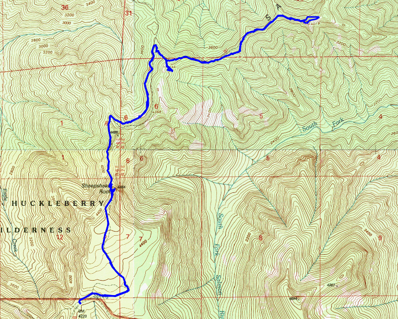
Today’s trip – wow – where to begin. Since everything past Fish Creek is still closed due to the fires, options were limited, but we originally planned the trip to go up the Plaza Trail and then out the Salmon Mountain Trail to the top of Salmon Mountain. We knew it was going to be a rather long day, but the day threw us a few curveballs. The curveballs just added to the epic nature of the trip.
We met Oliver in Estacada at 9 and headed up. There was a long line of fire vehicles headed out to the fires. When we got to Promontory, we headed up the 4610 road. They’ve done a lot of work on 4610 – at least to the Lookout Springs campground which makes it a pretty decent drive. Even so, it is about 18 miles from Promontory to the trailhead – it is shared with the east end of the Old Baldy trail. The last 4 miles are the hardest.
Shortly before we got to the trailhead, we stopped because there was a meadow of some sort and either Kirk or Oliver thought they saw some kind of trail heading into it. We stopped to look around but didn’t find much of a trail – the “meadow” was pretty swampy (kind of like Squaw/Tumala meadow). Since we didn’t have much luck, we piled back into the truck and continued up to the trailhead. When we got there, we were surprised to see another vehicle at the trailhead. We all assumed they were hiking the Old Baldy trail. We suited up and headed up the Plaza trail.
We hadn’t gotten too far up the trail when a lone woman came walking down the trail. She looked pretty freaked out and said she thought she heard a cougar scratching and chirping (they make kind of a chirping noise to communicate). She was so freaked out she decided to bail on her hike. It sounded like was planning to do the same hike we were planning. After chatting for a bit, we wished her well and continued up the trail. She had barely passed us when she turned around and ran back up the trail and yelled “can I join you guys?” None of us had any problem with her joining, so she joined the party. That was curveball one of the day. It turned out to be a very interesting curveball however.
After that excitement, we continued up the trail. The trail in this section is in remarkably good shape – we all agreed that most people that hike this come in to see the plane wreckage. The trail conditions kind of confirmed that theory. The trail definitely gets a lot more traffic to the plane crash site than it does beyond – either on the Plaza trail or the Salmon Mountain trail.
About a mile and a half up the trail is the first point of interest – Sheepshead Rock. There is a short side trail that takes you to the top of the rock. On a clear day it has great views, but going in this morning we could see nothing – we were still in the clouds:

After that, we climbed back down to the trail and continued our trek north. As we were going, we were looking for insulators – the first one we found was near the junction with the Salmon Mountain trail:

We also found a couple of sections of phone line laying on the ground which was kind of interesting.
When we got to the junction with the Salmon Mountain trail, you could see where most people go – the Salmon Mountain trail showed MUCH more activity than the continuation of the Plaza trail. I remember this when we did our backpacking trip in 2021 – once we got to this junction the trail conditions improved. The other thing I remember from the trip in 2021 was that there was a sign at this junction:

The sign was no where to be found today – not sure what happened to it, but I was thinking it was on the east side of the trail – but that picture shows it was on the west side of the trail. That was kind of a bummer, but we proceeded up the very steep section of the Salmon Mountain trail – it heads up to a saddle basically. At that point, there is a user trail that heads down to the crash site of West Coast Airlines Flight 956 from 1966. It is a sad story – the plane was brand new (15 days old) – they were just a little bit too low and slammed into the top of the hill – there were no survivors. Here is some of the wreckage – it is scattered over a very large area:

We looked around the wreckage – this was the third time I’ve visited this crash site, and you can tell that it has become more popular. There are now user trails all over the wreckage – when I came before none of these trails existed – you had to find the site and navigate the steep hillside and wreckage yourself. It is always a sad and somber thought when visiting the site – 18 people lost their lives in this crash.
After poking around the crash site for a bit, we headed back up the hill to the trail. It was getting close to lunch so we wanted to stop but we wanted to look for a sunny spot (it was still a bit chilly) – we found an open area with a bit of sun which was a good spot to stop. We stopped and ate lunch and then continued down the trail. I can’t remember if this was before lunch or just after but it was pretty early on the Salmon Mountain trail – we found an insulator with the phone line still hanging on it – you don’t see that very often:

We worked our way down the trail – it basically follows the ridge out to the lookout site. The further you get out, the brushier the trail gets. There isn’t a ton of blowdown thankfully but there were a couple of areas that were a bit difficult to navigate. There are some areas of pretty thick rhodies too.
We continued following the trail – as we got closer to the lookout site, I was remembering something odd from the last trip – I couldn’t remember the details, but I remember the approach to the lookout was kind of odd. We got to a junction in the trail – one part continued along the ridge and the other dropped down. We first continued along the ridge but we soon found that it didn’t go thru – or at least not very easily. We went back and took the other route – this was the weird route I remembered. The trail drops down quite a bit – it drops down to get around all the steep rocky outcroppings that make up the top of Salmon Mountain. It goes past the lookout to the east and then winds its way up the eastern flank of Salmon Mountain to the lookout. There is a good bit of this part of the trail that is pretty steep, but not terribly hard to get up.
We finally made it to the top of Salmon Mountain and saw the remains of the lookout:

We stopped up here for a while enjoying the views – I flew my drone – videos TBD.
The views from this site were pretty good to the south – trees have grown up on the north side so you couldn’t see much that way.
After 30 minutes or so on top, it was time to head back down. I think it was almost 3:00 at this point and we still had 5 miles to head back to the truck. When Oliver came up several years ago, he went up the way we went up, but he came back down the west side of the ridge. We decided to try that since it was a LOT shorter. This was the second curveball of the day. The beginning wasn’t too bad:

At some point we got cliffed out and had to hold on to rhodies and slide down a probably 60 degree hill – it was STEEP. Paige (our new trail friend) was behind me at the time and slid down the hill – I had to catch her so she didn’t slide too far. I had to help Thor in a couple of places because it was too steep for him. It was VERY STEEP. And Sketchy. Did I mention how steep it was? Thankfully, we all made it down the hill in one piece and got back down to the trail.
With that sketch part of the day done, it was clear why the trail took the route it did – it was all coming back to me from our trip back in 2017. If/when I ever do this trail again, I will take the trail to the east and then back up to the top.
We continued west on the Salmon Mountain trail – we made relatively good time – our two objectives on the way back were to see if we had any views from Sheepshead Rock and also to look at the old fireplace at the old Plaza Guard station that we missed on the way in.
It had been a pretty physical day – the trail wasn’t in the best shape, and then throw in that steep descent. We were all getting tired. We stopped a couple of times for water, but otherwise just soldiered on. We finally made it to the base of Sheepshead Rock and headed up. Kirk decided to leave his pack on the trail – I thought that was a good idea so I copied him. We made it up the pretty good user trail to the top and found a nice view


There was a small depression in the rock and Thor found it and got a drink. I took this photo of Paige and Thor taking in the views from the top of the rock – they were the “king of the hill”:

After enjoying the view for a few minutes, we all realized we needed to get back – it was getting late – at this point it was after 5:00 already and we still had another mile and a half to go. We headed back down to the trail and continued our trek south.
When we got to the spot where the trail takes a sharp turn to the west, we saw the fireplace – we were all surprised we missed it, but there is a tree kind of in front of it on the way up so it was partially obscured. We found it on the way back down:

We looked around the area a bit – there was a lot of stuff there back in the day – it is an interesting place to explore – and maybe even do some metal detecting. But that would have to wait for another day. We needed to get back to the truck.
We hopped back on the trail and as we were passing, Kirk contemplated where the plaza name came from – it means a “flat open area” – and this area on the trail certainly fits that description – it is a very flat area where the old Ranger station is.
We soon made it back to the truck – it was almost 6:30 by this point and we were all pretty tired from fighting brush all day long. It was a pretty epic day and the curveballs we were thrown only added to the “epicness” of the day.
Kirk and I capped the day at Fearless with a burger and a beer – the best way to end a great day of hiking!