
| Date | 8/27/2026 |
| Location / Trail | Fanton, Old Baldy and Plaza Lake Trails - 505, 501, 788 |
| Weather | Overcast to Sunny |
| Hiking Buddies | Olliver and Thor |
| Start / End | 11:00 AM – 4:50 PM |
| Distance / Elev | 11.25 miles 2800 ft elevation |
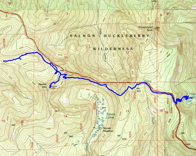
I wasn’t quite sure what today’s hike was going to be like. Originally we had planned to do some trailwork on another trail, but due to the Austin fire, it was inaccessible. There are some other options that we could have done if we wanted to drive around Mt Hood, but neither of us were too interested in doing that, especially since we were getting a late start. Oliver said he could show me the old campsite he found off the Old Baldy trail so we decided to head up there. It is relatively close so that worked well with our late start. I wasn’t quite sure what else we were going to do, or if we were going to have a short day. It turned out to be a very interesting (although much longer than I was planning) day.
We met up in Estacada and headed up. When we met there, Oliver told me that he had heard there were new closures due to the fires. It was then when I found that the majority of the trails I like to hike are now inaccessible due to the fires. Many of the ones that are accessible are only accessible via a very long drive to the back side of Mt Hood. That was kind of a bummer of news – it gave me a bit of PTSD from 2020.
We decided to head up from the “corner” on the Fanton trail – it is an old landing where the Fanton trail crosses the spur road and continues up to Old Baldy. We parked on the spur and headed up the trail. This trail gets more use that I used to think it does, especially from this landing. It is a pretty easy hike to the top of Squaw/Tumala mountain and it has some pretty good views from up there. The Fanton trail is in good shape up to its junction with Old Baldy. Once at the junction, we headed east. Oliver wanted to head up to the ridge to look for the old alignment of the trail. The Old Baldy trail is a very old route, predating the Forest Service. It was an old Indian Route. These routes typically followed ridgelines and were less well graded. When the Forest Service took over, they re-aligned some parts of the trail to make it easier for people and pack trains to use the trail.
We got up to the ridge – there were a few spots where it looked like it could have been tread – I think we even found a blaze or two, but all of it was pretty faint. I then decided to head up to a rocky outcropping on the ridge – it looked interesting and once I got up there, it didn’t disappoint:

The views weren’t great from up there due to trees, but it was still interesting. After that, we continued along the ridge for a bit, finding a reasonably good section of old tread that quickly disappeared. At that point, we decided to head back down to the trail and try and find the old campsite on the south side of the trail.
When we got back down to the trail, we came out just about at the spot where we think was an old outhouse – It is the only outhouse I’ve ever seen in the middle of a trail, but it seems to fit:

We then headed down to the south side of the trail to find the old campsite. He had found it a couple of years ago. It was pretty interesting. There were flat spots and a couple of old (very old) firepits:

After looking around a bit, we headed back up to the trail. As we were heading back up, we crossed an old alignment of the trail – I think it got re-routed to make it a little easier grade, but also because that older alignment had gotten very rutted – it was more of a runoff creek.
When we got to the junction that continued east, we headed south to go to the top of Squaw/Tumala Mountain. It was about lunch time so it was good timing. Unfortunately, we were pretty socked in at the top of the mountain (that would change later in the day):

After lunch, we poked around, finding the old outhouse for the lookout (it was behind the garage down below the lookout) as well as an old garbage pit.
We then headed back down to the junction continuing east. After this junction, the trail takes a few switchbacks and heads downhill. After the switchbacks, it continues east on a gradual downhill. At some point it starts gradually heading back uphill. We passed the side trail down to Squaw/Tumala Meadows – Oliver had asked me about it and I said that from my perspective, it wasn’t really worth the trip. The trail at the top isn’t too bad, but by the time you get to the bottom it all but disappears. Once you get down to the “meadow”, it is extremely hard to navigate due to the thick brush and you have to be very careful where to put your feet since it is braided with small “rivers”. I think it would have been slightly better today since it was pretty dry, but we would have still had to deal with all the brush. We decided to continue on the trail and head over to Plaza Lake instead. I’m glad we made that decision!
Past the trail down to the meadow, the trail goes thru a big rockslide. You get some nice views from here.

From here, we were able to see a bit of smoke from the Narrows fire along highway 224:

After soaking in the view from here for a bit, we continued east on the trail. The trail is in really good shape – almost no logs and surprisingly little brush on the trail. It goes thru very mature forest, sometimes with some steep sidehills, but it is a very pleasant walk thru this area of the trail:

We soon got to the east end of the trail at the 4610 road. We were kind of bummed to find that someone had broken the post with the trailhead sign and apparently stolen the sign. The post was laying on the ground with the sign nowhere to be found. I was at this trailhead last year and the sign was there then:

I never understand why people do stuff like this. That trail sign has been there for probably 15 years. I remember when they installed all these signs with some stimulus money. It annoys me to see stuff like this.
We then proceeded to walk down the 4610 road a bit until we got to the Plaza Lake trailhead. We had considered heading down the Plaza Creek trail, but I had my shorts on and wasn’t really prepared for off trail hiking – the Plaza Creek trail gets fainter and fainter the farther you get down the trail.
We headed down the Plaza Lake trail (all 17 switchbacks if I counted correctly!) – the beginning of the trail is in incredible shape – no logs, wide tread and almost no brush. As you progress down the trail, the condition degrades a bit. There are several downed logs, the tread gets narrower and some spots get pretty brushy. After what seemed like endless switchbacks, we finally arrived at Plaza Lake. There is a very steep “trail” down to a nice campsite right next to the lake. Next to the campsite is a VERY large doug fir tree – one of the largest I’ve seen in the Clackamas – I had Oliver stand next to the tree for scale – it is 6-8 feet in diameter:

Plaza Lake is a very nice lake – it is deep enough for fish and just a really nice looking lake:

There was an old snag that had fallen into the lake and Oliver decided to walk out to the end of it:

It was kind of sketchy because even though it was a pretty large log, it moved quite a bit. I opted to stay close to shore…..
After exploring the campsite for a bit and enjoying the lake, we continued around the lake – the trail becomes almost completely impassible in spots – way different than the whole trail up the hill. We got to the outlet of the lake. This was the spot I stopped in 2017, the last (only?) time I had been to this lake. Oliver wanted to explore the trail that used to head north from here up to the 2618 road off the Salmon River. I had my shorts on (not the right gear for tromping thru dense rhodies and brush) and it was getting late, but I said I’d go a little bit just to see what we found. We did find a little bit of tread but it quickly got lost in a sea of debris and dense rhodies. I let Oliver go on ahead – Thor didn’t really want to try and cross the outlet (there was a LOT of brush) and so I stayed back while Oliver looked for tread. He didn’t find a lot, but didn’t spend too much time looking either. We decided that further explorations would need to be done another day. We headed back.
We fought the trail until we go back near that first campsite. At that point, the trail improved dramatically. We then headed back up the 17 switchbacks – both of us felt like the trip back up was faster than the trip down. I find that sometimes happens – I think sometimes the anticipation of the destination makes it feel longer. It probably only took us 10-15 minutes to get up all the switchbacks – the trail drops about 600 feet to the lake in about a mile. Once back at the parking area, we headed back down the 4610 road. Oliver was ahead of me on the way up (he goes faster uphill than I do) and he saw a motorcycle on the 4610 road before we got up there. I decided to leash up Thor in case someone else came driving by. We headed back to the Old Baldy trail and back down it. We made really good time, even on the switchbacks up to the saddle where the trail to Squaw/Tumala mountain takes off. From that point to the truck, it was all downhill.
By the time we got back to the truck it was almost 5:00 – my feet were done for the day. I know Thor was tired – he jumped in the truck and laid down. We packed up and headed out. It was a very interesting day of exploration on some beautiful old trails.