
| Date | 8/26/2026 |
| Location / Trail | Upper Cripple Creek and Cache Meadow Trails - 702, 703 |
| Weather | Sunny with a bit of smoke |
| Hiking Buddies | Thor |
| Start / End | 11:00 AM – 2:00 PM |
| Distance / Elev | 5.4 miles 800 ft elevation |
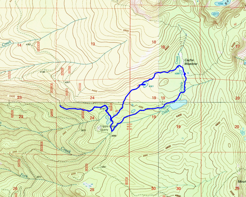
Today’s hike was intended to be a relatively short hike. I was planning to head out the following day and I’ve found that doing back to back hikes is tough on both myself and Thor, so I figured we’d make today a relatively easy day. Given the local fires and smoke, I wanted to find something that wouldn’t have much smoke – I really would prefer not to suck in a bunch of smoke while hiking. Heading up to Cache Meadow seemed like we should be far enough away from the smoke, so that was the plan with one addition – so we didn’t have to drive the 4635 road all the way to the top, start on the Cripple Creek trail where it crosses 4635 and head up from there. I had done this hike last year with Zack and it worked out pretty well. The plan was set.
We headed out a bit later than normal since I wasn’t sure if I should do the trip or not. As we were driving up, I was getting a bit concerned since it was pretty smoky. Fortunately, as we got higher, the smoke started dissipating. We made it up to the trail crossing and I took this picture of the smoke where we started:

We suited up and headed up the trail. The trail above 4635 is in pretty good shape – a couple of logs across the trail but nothing too bad. It wasn’t long before we got up to the 4635-140 spur road where the Cripple Creek trail ends. We walked down the road a little bit to pick up the Cache Meadow trail – there is a signpost with a “trail” sign on it, but no real trailhead sign with a trail name/number or anything. Something I don’t recall ever seeing (although I haven’t hiked this end of the trail very many times) – An old registration box – this is where the trail crosses the wilderness boundary (even though there is no sign):

We worked our way up the trail, and we soon got to the first of a few small meadows – this is before Cache Meadow proper:

We continued our way up the trail and soon came to another small meadow that earlier in the season has water in it – a “lake” of sorts:

We ventured out into the meadow to look at the white area – it was pretty interesting. There were a number of animal prints in the meadow – Elk, deer and I think bear. The white stuff was all cracked but the interesting part is that it was REALLY hard – I was expecting it to be very soft:

After exploring the meadow a bit, we continued on the trail. The trail was in OK shape – a bit brushy in places but it also had a fair number of downed logs – some of them rather large:

A bit further down the trail we got to the beginning of Cache Meadow proper:

We got to the campsite at Cache Meadow where the old cabin used to sit (it burned down in the early 2000s – I never saw it). We stopped here to have some lunch and drink some water. After lunch, we headed down “Trail X” – At some point I swear I saw some reference to this trail as Cripple Creek but I can’t seem to find it now. The old Trail Info sheets refer to it as “Trail X” – it goes by the un-named lake – I call it Cripple Creek Lake since Cripple Creek feeds it:

It is a nice lake – I’m guessing there are fish in it since it is most likely deep enough. Thor tried to go into it (he likes to cool off in the water), but it was so low the edges were really muddy. He sunk in probably at least 6″. Thankfully, I was able to convince him not to go any further.
We made our way around the lake and continued down – at the south end of the lake there is a huge mess of downed logs – I seem to recall this from prior trips:

We continued on the trail and soon got to the un-named north/south connector trail that would return us to near the beginning of the Cache Meadow trail. It is at the confusing 5 way junction near where the trail begins. It was interesting – someone did a bit of work near the trail junction:

There was a little bit of lopping at the beginning of the trail as well, but it soon became very overgrown – we fought our way thru it and soon the trail cleared up a bit and was pretty good until we got to the weird 5 way junction. We made the correct turn here and went back to the 4635-140 spur road and then walked back up the road a bit to the Cripple Creek trail and then back down to the 4635 road.
It was a short day, but it was a really nice day. We did over 5 miles in about 3 hours – I didn’t feel like we were really trying to go too fast but we made pretty good time. I’m glad I decided to head out today – this area is a neat area that is underappreciated.
Post hike edit: The day following the hike, this trail became completely inaccessible due to closures for the Austin Fire. I’m even more glad I did this trip!