
| Date | 8/1/2026 |
| Location / Trail | Anvil Lake Trail - 724 |
| Weather | Mostly Sunny |
| Hiking Buddies | Thor |
| Start / End | 10:05 AM – 12:45 PM |
| Distance / Elev | 5.6 miles 500 ft elevation |
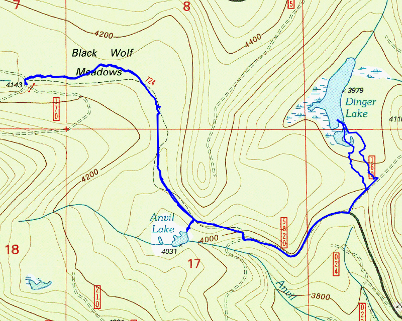
After recent work trips, I wanted an easier day out. I’ve been thinking about trails I haven’t hiked in a while and Anvil Lake keeps popping up. It is a relatively flat, relatively short trail, so it seemed like a perfect choice. I decided to add a short excursion over to Dinger Lake which was well worth the trip.
We headed out about the usual time and made good time to the trailhead. When we left the house, it was misting just a bit – I was concerned we were going to get wet, but as we got closer to the trailhead, things cleared up. When we got there, as expected, there was no one else there. That would not be the case the whole day, however. The last time I hiked this trail was back in 2013 (I did hike a portion of it in 2017 when we were looking for the old Buck Lake trail which intersects this trail near the meadow), and I note in my trip report from 2013 that the trail was busier than I had expected. Today was no different.
We parked at an old decommissioned road junction near the trailhead and headed east on the trail. The trail in this area is very flat and the understory is pretty sparse, but it is kind of interesting:

It isn’t too far and the trail really starts to open up as it approaches Black Wolf Meadow:

And a bit farther you enter into Black Wolf Meadow proper:

We walked thru the meadow, which was surprisingly easy – the path was mostly very evident, unlike the route thru the Cottonwood Meadows which is pretty faint. We followed the posts thru the meadow and soon got to the spot where the trail started heading back into the woods on the east end of Black Wolf Meadow:

At this point, the trail gets back into trees, but it has a very open corridor, which is kind of interesting. This is an example of what it looks like in this area:

It isn’t too long until you come upon the crossing of Anvil Creek – it was all dry today unlike the last time I was here:

A little past this creek crossing, I came upon the first other hikers/hunters I encountered today. It was a man and woman. We chatted for a bit – I thought they said it was the first day of bird hunting but later I asked them what kind of birds they were hunting they said bear. I guess August 1st is the first day of bear season. After chatting a bit, we parted ways – they continued west while we headed east.
A little bit farther is the short side trail down to Anvil Lake. It is a pretty small, shallow lake with a small campsite next to it:

After checking out the lake, we headed back up to the trail and continued east. Just past the lake turnoff, I was surprised to encounter a small burned area – it was not big, but it looked like a relatively recent fire (within the last few years):

The trail thru the burned area was easy to navigate, unlike some of the burned areas. I wonder if this was a lightning strike or something? It does not show up on the historical fire layer at all.
We continued on the trail, and soon dropped down to the 5820 road which is the eastern trailhead for this trail:

The next segment of the trip was a short side trip over to Dinger Lake. Originally I was going to drive over there but then I started looking at the map and it wasn’t very far to walk up the 5820 road and then take a short side trip up the 160 spur and head cross country over to Dinger Lake. It looked very flat in there and looked pretty easy.
The 5820 road was gravel but I was surprised to find the 160 spur was paved! I don’t ever recall seeing a paved spur road before. The older maps show 5820 being paved from the east up until the 160 spur, so maybe they just paved it way back when. We walked up the 160 spur to a spot where it looked relatively easy to get over to Dinger Lake. At first I was a bit worried since it was a bit thick, but once we got out of the road prism it cleared up pretty well. As we got closer to the lake I started seeing lots of flagging. At first I thought maybe this was the continuation of the trail (the Anvil Lake trail was part of the much longer Clackamas Lake trail which went from Estacada all the way to Clackamas Lake), but I never saw anything that really looked like tread, nor any blazes or anything at all making me think this was a trail. Here are a few of the flags:

Since that did not appear to be a trail, I didn’t try and follow it too far – I just wanted to get out to the lake. We broke thru the woods and came out into the south end of Dinger Lake which was dry – although you could tell it had standing water in it earlier in the year:

We stopped in this area so that I could fly my drone to explore the rest of the area. I wasn’t sure how much water was in Dinger Lake. I flew the drone to the north end of the lake and did indeed see water. I then flew around the south end of the “lake” (it is more of a meadow this time of year) and then landed.
Here is the drone video:
After that, we walked up as far as we could to the south end of the lake. Dinger Lake is kind of an interesting lake, although it is pretty shallow:

After exploring around for a bit, we walked back down the length of the “lake” (meadow) and then re-entered the woods and went back out on the 160 spur. We walked it back down to the 5820 road and while we were walking back, we encountered the hunters we had met earlier in the day at Black Wolf Meadows.
We continued back down 5820 and then headed west on the Anvil Lake trail. It was nearing noon and I thought having lunch at Anvil Lake would be a good spot. We soon got back down to the lake and had a quick lunch. When I looked at the pinpoint forecast for the day, it said there might be rain later in the afternoon, but by noon it was already clouding up and I was a bit worried we might either get wet or get stuck in a thunderstorm like we had on Rho Ridge a few weeks ago. We ate a quick lunch and then headed back.
Right after we left the campsite next to the lake, I saw this box nailed to a tree – I’m pretty sure it was several fishing flies in the box – I’m not sure WHY they were there, but it was kind of interesting:

We got back up to the trail, and then continued west. When we got to the meadow, I stopped and flew my drone. I hadn’t seen anyone else, and I had Thor on the leash, but I didn’t tie him up. While I was flying my drone, another hunter with a dog entered the meadow and Thor and him got into it. I had to apologize to the hunter. I then tied Thor to a tree while I finished my drone flight. I need to make sure he is on a leash on any trail that might have other people. He is fine with people but gets snippy with dogs he does not know. I should know better….
Second drone video TBD
I finished my drone flight and then packed up and headed back to the truck. While we were walking thru the meadow we had some mist come down. Thankfully, it wasn’t much and it wasn’t continuous. We got back to the truck before 1:00 – the other hunter was parked here and was packing up as well. We headed out. As we were heading down the 58 road there were 2 more hunters on the road near a thinned area. So we saw a total of 5 hunters today! Crazy!
It was a really good trip – I can’t believe it has been so long since I’ve been on this trail but it won’t be that many years before I hike this again. It is a very interesting area.