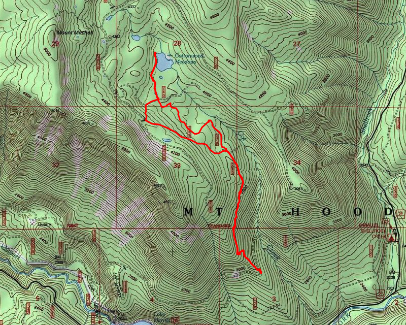
Location of Hike: Lower Cottonwood Meadows Trail
Trail Number: 705
Weather during Hike: Overcast to partly sunny with rain, snow and sleet
Hiking Buddies: Kirk, Zack, Ollie, Thor
Start Time: 10:15 AM End Time: 2:20 PM
Hike Distance: 5.5miles Elevation Gain: 1500 feet
Due to the warmer than normal weather we’ve been having, we were able to easily make it to the lower trailhead at almost 3000′. It wasn’t really raining when we got there, so we quickly suited up for extreme weather and headed up the trail. The trail basically follows the ridge up to an old clearcut below Cottonwood Meadows. The lower portion of this trail is in some magnificent old growth with tread in really good shape:

We did encounter quite a few downed logs and a few messes on the beginning of the trail, but we cleaned up what we could and went over/around what we couldn’t. It wasn’t too long before we popped up onto the 5830-265 road where we saw just a little bit of snow:

We walked up the road and then went cross country thru the clearcut (the trail thru the clearcut was wiped out). After a few attempts at making sure we were going the right direction, we got up tp the 240 spur crossing where there was more snow. Beyond this crossing the real trail continues north:

Right after that crossing, we got to the first, lower Meadow, which looked mostly frozen over:

And then continued north thru a couple of small little meadows towards Cottonwood Lake:

And shortly arrived at a mostly frozen Cottonwood Lake (although none of us wanted to try it out to see how frozen it really was!):

We ate lunch there and looked around a bit and then headed out. When we got to the 240 spur, we decided to walk back the road rather than going cross country, since it was rather difficult – there was a lot of melting snow water runoff which added to the difficulty of getting thru the clearcut. The plan was to head west until the road turned and then head uphill to the upper road – this would cut quite a bit of time off the trip – almost a mile of road walking it looks like.
We made it up to the road turn and then up the hill – from there we went uphill and soon found the upper road that had been bermed at an old gate location. It was in this section I took some photos of Thor having fun in the snow:

He had lots of fun with Ollie – running around and doing his beaver thing in the snow and even doing some frapping at one point.
We finally came back to the 265 spur and things had cleared up a bit from what they were in the morning – we still got gusts of wind occasionally but there was even a few small spots of blue sky at times – You can sort of see Mt Mitchell in the background (in the clouds behind the trees):

We headed down the road and onto the old trail and quickly made it back to the truck, doing a little bit of trail maintenance along the way – cutting out some smaller trees.
Since it was still somewhat early, we decided to drive down to the end of the road and check out the collapsed bridge over Cot Creek:

It is really growing in – it was interesting to see how much work went into building that bridge too – there was a LOT of cribbing on each approach.
After checking out the bridge we headed back to town – we wanted to stop at Fearless but they were closed for New Years Day. We headed over to the Wagon Wheel Saloon (I had been there once with Don) for a beer and some appetizers.
It was a very interesting day on a beautiful old trail in a very interesting area. The winter weather warning didn’t really seem to come to pass – other than a few gusts of wind and a little bit of rain, sleet and snow at times, it really wasn’t that bad up there. I was expecting to get a LOT wetter than we did. I wasn’t even sure we would be able to make it up all the way due to the wind. It turned out to be a pretty good middle of winter day in the woods. A good start to the new year.

