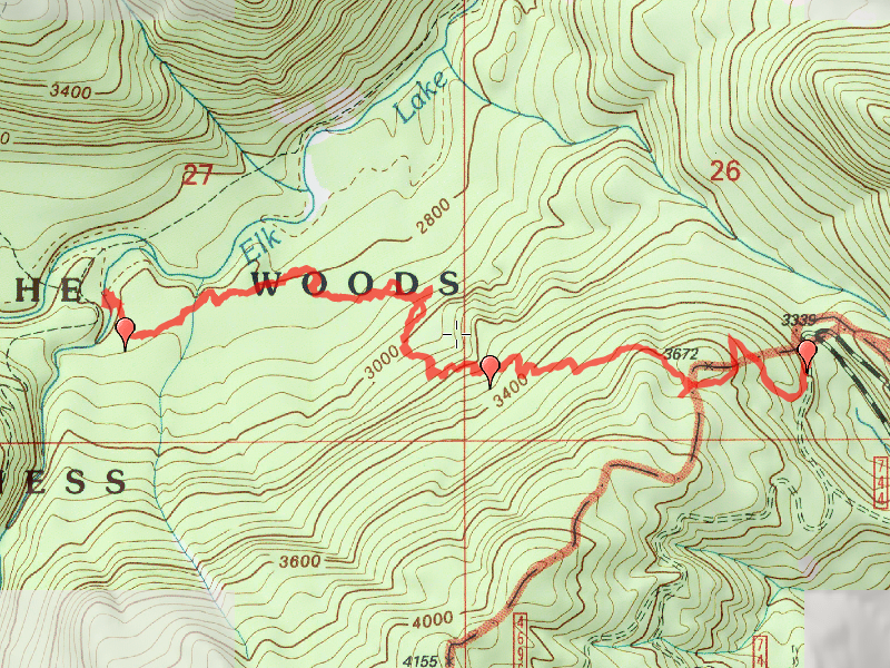
Location of Hike: Old Trail East of the Battle Creek Shelter
Weather during Hike: Sunny, but cold and windy
Hiking Buddies: Bodie (my dog)
Start Time: 10:00 AM End Time: 2:10 PM
Hike Distance: 4.4 miles
So I had the day off (Veteran’s Day) and went up and hiked this trail. Thanks to the wonderful description, and a copy of the track, we were able to follow most of the trail. It gets pretty iffy in the middle – LOTS of blowdown and the tread gets less discernible along with LOTSs of rhodies. It is obvious this trail has not seen real work in a long time – and no hikers for a long time either. The tread is covered in moss, but most of the route does have intact tread. It is actually pretty amazing that it is still hikeable (although with a fair bit of difficulty). A day or two of lopping/brushing and maybe a bit more flagging in a few spots would make this trail relatively easy to hike.
We headed up the old road to find the cairn that marked the start of the trail. The directions I was given were very good, and we had no problem finding it. We headed through a rhodie thicket (on old downed logs to minimize the fighting the rhodies) and soon came to the other side of the rhodie meadow – we found tread! And flags! We followed these for quite a ways pretty easily. In the middle the trail starts to get rather vague – I think we pretty much kept to the tread (there are blazes all along the way). We continued down the trail until we found a flat spot with an old old sign:

We continued on down to the creek – at the creek there are a LOT of REALLY BIG logs down, which were a challenge to navigate around. We decided not to cross the creek – it was pretty cold and the creek runs pretty high. We stopped to have lunch, enjoy the sights and sounds of the creek, and then headed back up the hill.
Going back up was a little tougher than coming down. We lost the trail a couple of times at difficult points, but picked it back up after getting our bearings and looking around a bit. On the way back up we found a few interesting things. One was a section marker cut into a tree – this was very close to a section line – kind of cool:

This tree looked like it was the location of old sign maybe?

This next photo might have been an old junction – it was just about at the halfway mark on the trail. You can’t really see much tread to the right (the trail heads to the left – you can see a flag). But the tree to the right looks double blazed and it looks just like an old junction would look – and there is a bit of tread heading down to the right – it just doesn’t go too far:

And lastly, on the way home I took this very sad photo of Detroit Lake – I don’t know if is it always this low this time of year or not. Wondering if they drain it down really low to allow water to accumulate over the winter? It looks like the water level is at least 50′ below where it should be. All those docks are sitting WAY high and dry.

When we got back to the truck, I realized it was colder than I thought – my boot laces were FROZEN! But we left feeling good that we could find this very old trail. A bit chilly (the heater in the truck felt REALLY good), but satisfied at successfully hiking another old abandoned trail.

